Toronto and Region Conservation Authority Flood Forecasting and Warning System - Delft-FEWS
Toronto and Region Conservation Authority Flood Forecasting and Warning System
11 April 2023
Flooding and increasingly extreme weather events are the leading cause of public emergencies in the province of Ontario in Canada. The Toronto and Region Conservation Authority (TRCA) provides environmental protection and natural hazard management to mitigate the risk of flooding and erosion and plays a key role in providing municipalities with the information they need to respond to flooding. TRCA’s jurisdiction includes nine watersheds and their Lake Ontario shorelines, which is home to almost 5 million people. TRCA’s new Flood Forecasting and Warning System (FFWS) supports decision-making and communication about flood risk in this region.
A principal mandate of the TRCA is to reduce the risk to life and damage to property caused by flooding. They do this by providing local agencies and the public with notice, information, and advice so they can respond in advance of and during severe rainfall events and flood-related emergencies.
TRCA has developed an extensive protocol for the daily assessment of forecasted weather and lake conditions, which is structured in their Daily Planning Cycle (DPC). Part of the DPC is to assess a range of numerical weather predictions and other data sources to determine the risk of flooding by rain, snowmelt, thunderstorms, and local Lake Ontario waves and storm surge.
Previously, the DPC required forecasters to manually enter data and review several weather forecast products and reports from websites and emails. These tasks were laborious, and the results were likely to differ depending on the person performing them.
TRCA asked Deltares to develop a Delft-FEWS-based application that would automate these tasks, do the calculations at a finer resolution, and provide a foundation for later expansion with integration of hydrological models. With the time saved from these improvements, staff can now allocate more time to decision-making and communication about flood risk.
FFWS was developed and implemented in a way that allowed the TRCA team to make informed design decisions, while gradually integrating it into the DPC. This allowed the team to test the system and compare it with the existing tools, while providing end-users time to become familiar with the new FFWS application.


In the first phase of the project, a base platform was set-up that automatically collects data from several sources:
- Meteorological and hydrological observations from the TRCA telemetry network, Water Survey of Canada, and the Department of Fisheries and Oceans.
- Numerical Weather Predictions (NWP) from Environment and Climate Change Canada (ECCC) (HRDPS, RDPS, and GDPS) and the US National Oceanic and Atmospheric Administration (NOAA) (HRRR NAM, GFS, and QPF).
- Wave and water level forecasts for Lake Ontario from ECCC.
All data are postprocessed and aggregated to daily timesteps, in line with the flood warning procedures of TRCA.
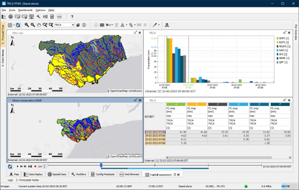
Dashboard showing rainfall volumes from different NWP in one place.
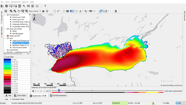
Wave height forecast for Lake Ontario.
In the second phase of the project, workflows for further assessment of the forecasts were developed. These focus on several aspects of TRCA’s flood forecasting procedures: (1) rainfall volume, (2) summer runoff volumes, (3) winter runoff volumes, (4) ice jam potential, (5) thunderstorms, (6) lake conditions, and (7) dam status. For each of these assessments, FFWS performs additional calculations that replicate those in the DPC. This workflow runs once per day, generating all the information needed for the forecaster on duty to draft the daily communication for flood potential.
The imported and processed data are disseminated through the Delft-FEWS web services and retrieved by the DPC Excel report formatter. With this new connection, the DPC report contains all the information for a first assessment of potential for flooding in the upcoming days. Further analysis can be done using the FFWS Operator Client, which shows all imported and processed data in informative and clear displays.
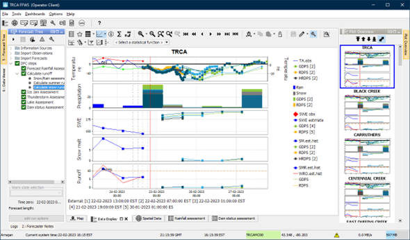
Calculations are done for all watersheds in the TRCA jurisdiction.
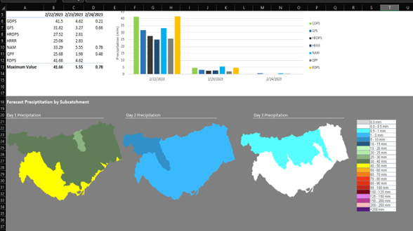
FFWS data are disseminated via the Delft-FEWS web service, which is accessed by the DPC Excel workbook.
The FFWS is one of the first Delft-FEWS-based urban flood forecasting systems in North America that directly ties in with an active standard operation procedure. It is also unique in that it takes a multi-hazard perspective, analyzing floods caused by different drivers. It is also the first time a direct connection has been made between an Excel-based report and the Delft-FEWS PI REST web service.
The FFWS provides TRCA with a solid basis for consolidating and further expanding its flood forecasting capabilities. In a future phase, TRCA plans to extend the functionality of the FFWS by integrating hydrological models. Furthermore, TRCA is exploring integrating telemetry data from neighboring jurisdictions to further improve their situational awareness.


